
Subscribe
Winter Strikes Back: A 30-Degree Plunge for Battle Creek
The spring warmup vanishes as arctic air returns, bringing snow showers and single-digit wind chills.
March Madness: From Mild Rain to an Arctic ReturnBattle Creek faces a dramatic 30-degree temperature drop this week as winter reasserts its grip.
The "Spring Surge" is hitting a major roadblock.
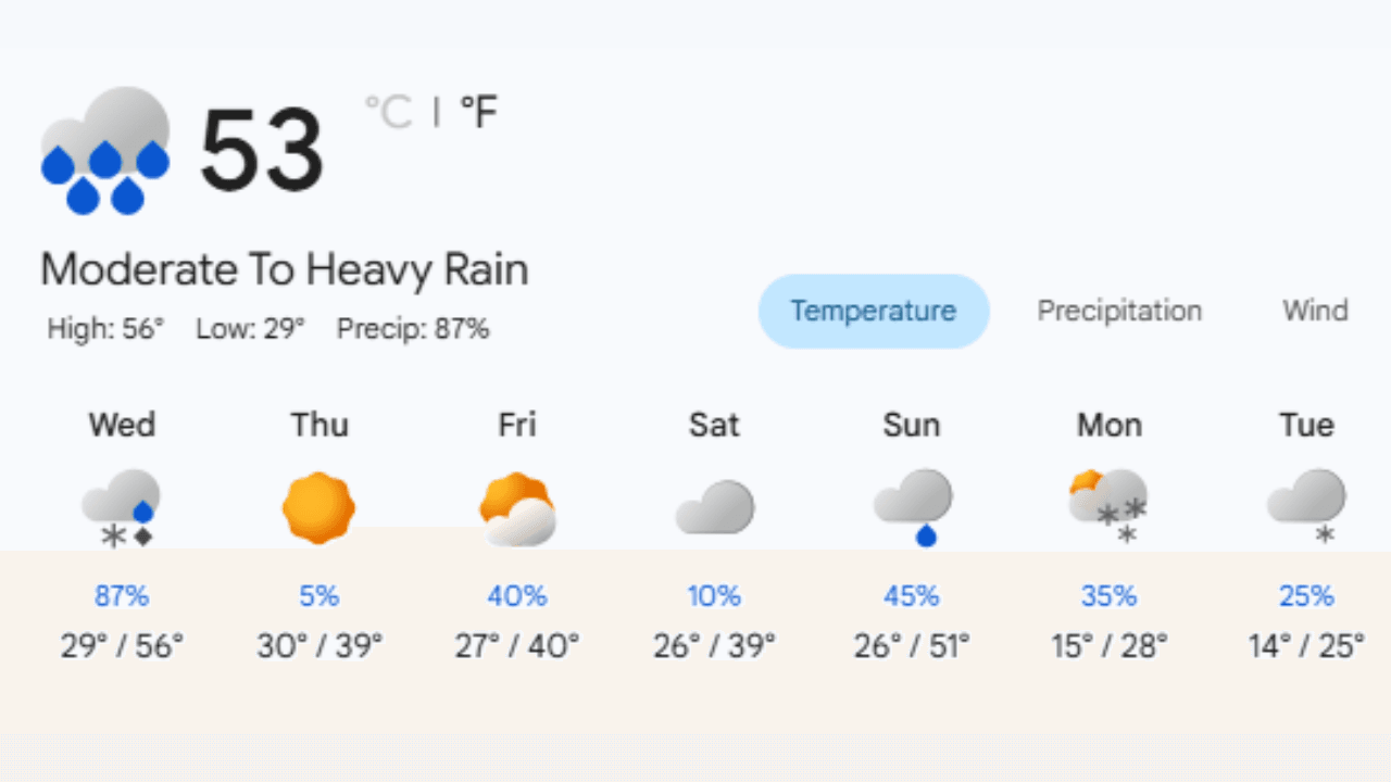
While we’re starting the week with temperatures in the mid-50s, a powerful cold front is set to sweep through the Cereal City, bringing rain, snow, and a return to the deep freeze by early next week.
Wednesday will be the transition day, starting with rain and snow and a high of 56°F before the colder air begins to pour in. By Thursday, temperatures will plummet, struggling to reach 39°F.
This downward trend continues throughout the week, with consistent chances for snow showers.
The most significant shift arrives next Monday and Tuesday, where daytime highs will barely crack the mid-20's ... nearly 30 degrees colder than where we started.
With humidity levels reaching 95% early in the week and gusty western winds up to 28 mph on Friday, it will feel even colder than the thermometer suggests.
If you were thinking about putting the snow shovel away, you might want to keep it handy for at least one more week.
Winter isn't ready to let go of Battle Creek just yet!
Cereal City Weather Q&A
Q: With temperatures hitting 56°F on Wednesday, is the rain-snow mix going to cause icy roads? A: Yes, there's a significant risk. Wednesday begins with rain and snow and a high of 56°F, but the temperature is expected to drop sharply to a low of 29°F by nightfall. This rapid cooling, combined with an 87% chance of daytime snow, means that any wet surfaces could quickly freeze, leading to slippery conditions.
Q: How windy will it get during this cold snap? A: Friday is expected to be particularly blustery. While the high will be a seasonal 40°F, west winds are forecasted to reach speeds of up to 29 mph. This will make the air feel much colder than the thermometer indicates, so you'll definitely want to keep that windbreaker or heavy coat handy.
Q: Is there any sunshine to look forward to amidst all the snow showers? A: There is! Thursday, March 12th, is looking like the bright spot of the week. After the rain and snow clear out on Wednesday night, Thursday is forecasted to be sunny with a high of 39°F. It will be a crisp but beautiful day before the clouds and snow showers return for the weekend. |
Stay up to date with our local news!
Get articles like this delivered to your inbox.
THIS PUBLICATION SPONSORED BY