
Subscribe
From Flurries to Floods? Battle Creek’s Warming Trend
Winter holds on through Valentine's Day before a rainy, warm surge takes over early next week.
Sunshine for Sweethearts: Battle Creek’s Weekend Outlook
Saturday offers perfect winter weather for Valentine’s plans before Monday’s rain arrives.
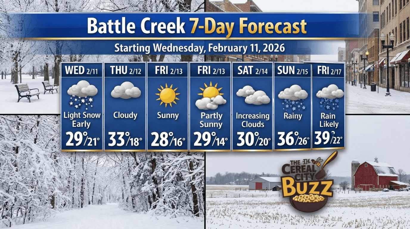
Battle Creek is in for a weather "flip-flop" this week, moving from a crisp, traditional Michigan winter into a soggy mid-February thaw.
We start the stretch with some light lingering snow on Wednesday, but the real highlight of the week is the stretch of quiet, beautiful weather perfectly timed for Valentine’s Day weekend.
Friday and Saturday are looking like the gems of the week.
While it will be chilly, with overnight lows dipping into the mid-teens, the skies will clear to provide plenty of sunshine.
Saturday, in particular, will be a crisp 29°F under partly sunny skies, making it a picturesque day for any local dining or downtown plans.
It’s the kind of classic winter weather that makes the Cereal City look its best.
However, don't leave the house on Monday without an umbrella.
By the start of the work week, the arctic air retreats, allowing a warmer, moisture-rich system to move in.
Temperatures will surge toward the 40s, turning any potential snow into a steady rain for Monday and Tuesday.
While the melting snow might make for a messy commute, the break from the freezing cold will be a welcome change for many.
Cereal City Weather Q&A
Q: Is there any significant snow accumulation expected for Valentine’s Day? A: No, the forecast for Saturday, February 14th, is looking very stable. We are expecting partly sunny skies with a high around 29°F. While it will be chilly, you won't have to worry about shoveling before your Valentine's dinner plans!
Q: When should I expect the transition from snow to rain to occur? A: The shift happens late Sunday night into early Monday morning. As warmer air moves in, the thermometer will climb into the mid-30s, meaning your Monday morning commute will likely be wet and slushy rather than snowy. Keep your umbrella and waterproof boots handy for the start of the work week.
Q: With temperatures hitting the high 30s by Tuesday, is the "January Thaw" finally here to stay? A: While 39°F feels like a heatwave compared to last month, it’s a bit early to call it a permanent spring. This is a classic mid-February "mini-thaw." It will definitely melt some of the existing snowpack, but Michigan winters usually have at least one or two more cold snaps in store before spring truly arrives in Battle Creek. |
Stay up to date with our local news!
Get articles like this delivered to your inbox.
THIS PUBLICATION SPONSORED BY