

Battle Creek Weekly Weather: September 16-22 Forecast
Battle Creek Michigan weather forecast for Sept. 16-22, 2026. See the Battle Creek 7-day forecast, daily highs and lows, rain chances and thunderstorm timing.
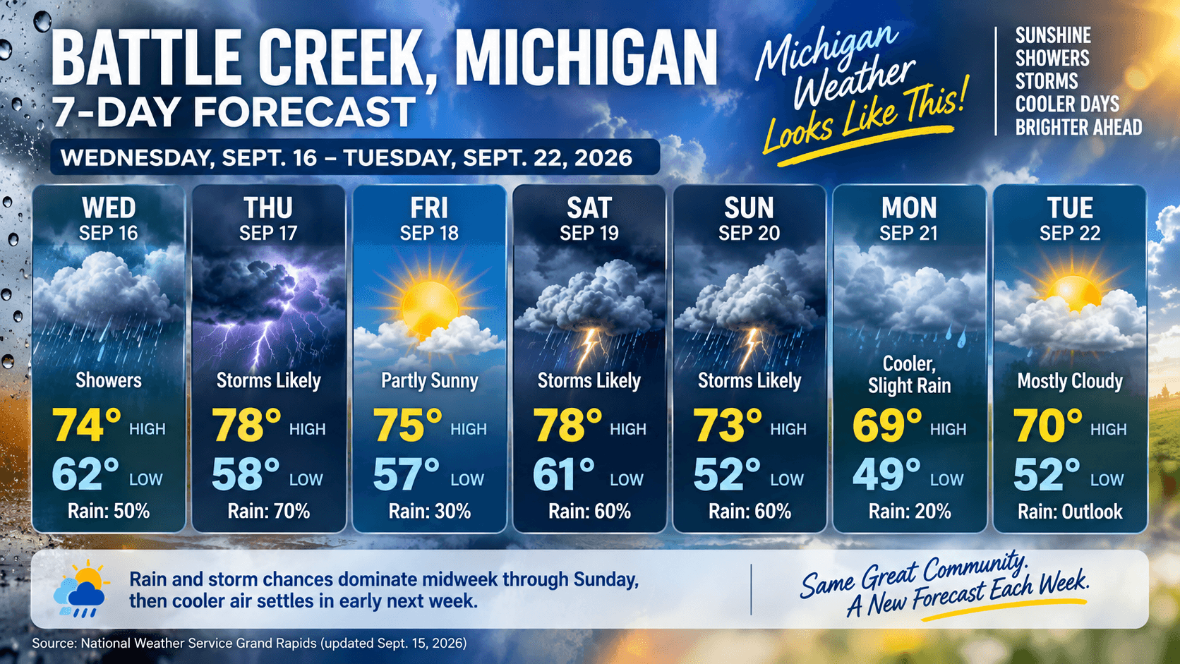
Battle Creek Weekly Weather: September 16-22 ForecastBattle Creek and Calhoun County are heading into a changeable, storm-aware week. The National Weather Service forecast calls for rain or thunderstorm chances from Wednesday into Sunday, with the most meaningful chances Wednesday night, Thursday, Saturday and Sunday. Highs generally stay in the 70s before cooler air moves in for Monday.
Wednesday starts with a chance of showers and a high near 74. A stronger round of showers and thunderstorms is likely Wednesday night, followed by another likely storm period Thursday morning into early afternoon. Weekend plans will need flexibility as thunderstorm chances return Saturday and Sunday.
The early-week change is notable: Monday’s high is forecast near 69 with a low near 49 Monday night. Tuesday is beyond the detailed NWS seven-day period as of this update, so its temperature outlook is cross-checked with AccuWeather and should be revisited before weather-sensitive plans.
Battle Creek 7-Day ForecastWednesday, September 16: Partly sunny with a 50% chance of rain showers. High near 74; low near 62. Northeast wind around 3 to 7 mph. Rainfall amounts could reach one-tenth to one-quarter inch where showers develop. Showers and thunderstorms become likely Wednesday night.
Thursday, September 17: Showers and thunderstorms likely before 2 p.m., then mostly cloudy. High near 78; low near 58. The NWS chance of precipitation is 70% during the day. West wind around 7 mph. Thursday night trends mostly cloudy and quieter.
Friday, September 18: Partly sunny and more settled. High near 75; low near 57. Only a small daytime rain chance is indicated, but a chance of showers arrives after 2 a.m. Friday night, with the night chance around 30%.
Saturday, September 19: A chance of showers early, then showers and thunderstorms likely. Partly sunny with a high near 78; low near 61. Precipitation chance is around 60% during the day and storms remain likely Saturday night. South wind 10 to 14 mph.
Sunday, September 20: Showers and thunderstorms likely before 2 p.m., followed by a slight chance later. Partly sunny with a high near 73; low near 52. Daytime precipitation chance is around 60%. A north-northwest wind near 13 mph signals the beginning of the cooler change.
Monday, September 21: Cooler and partly sunny, with a slight chance of showers and thunderstorms before 2 p.m.. High near 69; low near 49. The NWS daytime precipitation chance is near 20%, with a northeast wind around 9 to 13 mph.
Tuesday, September 22: Extended outlook: mostly cloudy with a high around 70 and low around 52, based on AccuWeather’s current daily outlook. Detailed NWS precipitation and thunderstorm timing was not yet available for Tuesday when this article was updated. Check the NWS forecast again before making outdoor plans.
What to Watch This Week
Forecast details are based primarily on the National Weather Service forecast for Battle Creek, issued by NWS Grand Rapids and checked Sept. 15. Tuesday’s temperature outlook was cross-checked against AccuWeather’s Battle Creek monthly forecast. Forecasts can change, especially with thunderstorm systems, so check the NWS page again for updates or alerts.
Questions You Might HaveQ: Will it rain in Battle Creek this week? Q: What is the best day for outdoor plans in Battle Creek? Q: Is Battle Creek getting colder next week? |
Stay up to date with our local news!
Get articles like this delivered to your inbox.
Subscribe Now
Sep 15, 2026
Battle Creek and Calhoun County events, Sept. 16-29
A fresh two-week guide to local things to do.

Sep 15, 2026
Current Battle Creek and Calhoun County jobs
A fresh, employer-by-employer roundup of local openings.

Sep 15, 2026
A Bedford Township ranch with room to spread out
A current local Featured Home listing.

Sep 15, 2026
Police-chief transition ahead
What is confirmed and what remains pending.
2 Comments
Join the conversation
gotta keep an eye out for the thunderstorms. Hope my bbq friday isn’t a wash out.
Thanks for reading! Friday looks like the best window for grill plans, with only a small daytime rain chance, just keep an eye on the forecast for any late-night shower updates.